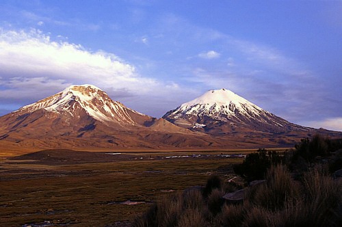
Volcano Nevados de Payachatas
Archaeological
Culture & History Tours
Nature & Adventure Tours
The Parinacota
volcano (6,348 m above sea level), is located at 18ºS and 69ºW, in the
Region of Arica and Parinacota, in the extreme north of the country. This volcano is distributed within the 'Lauca
National Park', which since 1970 is administered by the National Forestry Corporation (CONAF). Together with the Pomerape volcano (6,222 m a.s.l.), located to the north, they form the so-called 'Nevados de Pachayata', whose summits are covered by glaciers.
The Parinacota
volcano is of the composite type, being constituted by flows of andesitic lavas and dacitic domes, forming an almost symmetrical cone. The lava flows, as well as blocks with prismatic diaclastic (PJB) and volcanic pumps, can be observed towards the flanks of the
volcano.
For this volcano, five stages have been defined that mark its eruptive evolution. One of these stages corresponds to the partial collapse of the cone, which occurred about 8 ka A.P. ago. This collapse gave origin to a debris avalanche deposit, distributed by ca. 23 km towards the west flank of the
volcano.
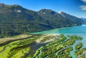
This deposit constitutes a field of well preserved hills, covering an area of 140 km2 and a volume of ca. 6 km3. The hills seen in this deposit reach heights of 100 m and are distributed over the surface of the Cotacotani Lagoon (6 km2, 4,500 m above sea level), giving it a characteristic geomorphology. On the other hand, the origin of the current Lake Chungará (21.5 km2, 4,520 m a.s.l.) is linked to the genesis of this deposit.